
Dublin offers a perfect blend of urban charm and natural beauty that makes it an ideal destination for walking enthusiasts. Beyond the city’s famous pubs, vibrant music scene, and rich history lies an extensive network of walking trails catering to all fitness levels. From leisurely strolls along the River Liffey to challenging hikes in the nearby Wicklow Mountains, Dublin provides diverse landscapes for every walker to enjoy.
This comprehensive guide covers the best walks in Dublin and nearby, featuring urban explorations, coastal adventures, mountain treks, and historic routes. Each walk includes essential information about distance, difficulty, notable features, transportation options, and recommendations for post-walk refreshments. Whether you’re a visitor to the Emerald Isle or a local looking to discover new paths, these Dublin walks will help you experience the city and its surroundings from a fresh perspective.
City Walks in Dublin
Dublin Docklands and Grand Canal Walk
- Distance: ~3 km one-way (6 km return)
- Difficulty: Easy (flat, paved paths suitable for all fitness levels)
- Duration: 1-1.5 hours
- Notable Features: Modern architecture, historic dockyards, Dublin Convention Centre, Samuel Beckett Bridge, Grand Canal Square
- Best Time: Year-round, evenings for spectacular city lights
- Transport: Accessible by Luas (Red Line) to Spencer Dock or Mayor Square
- Facilities: Public toilets, numerous cafés and restaurants en route
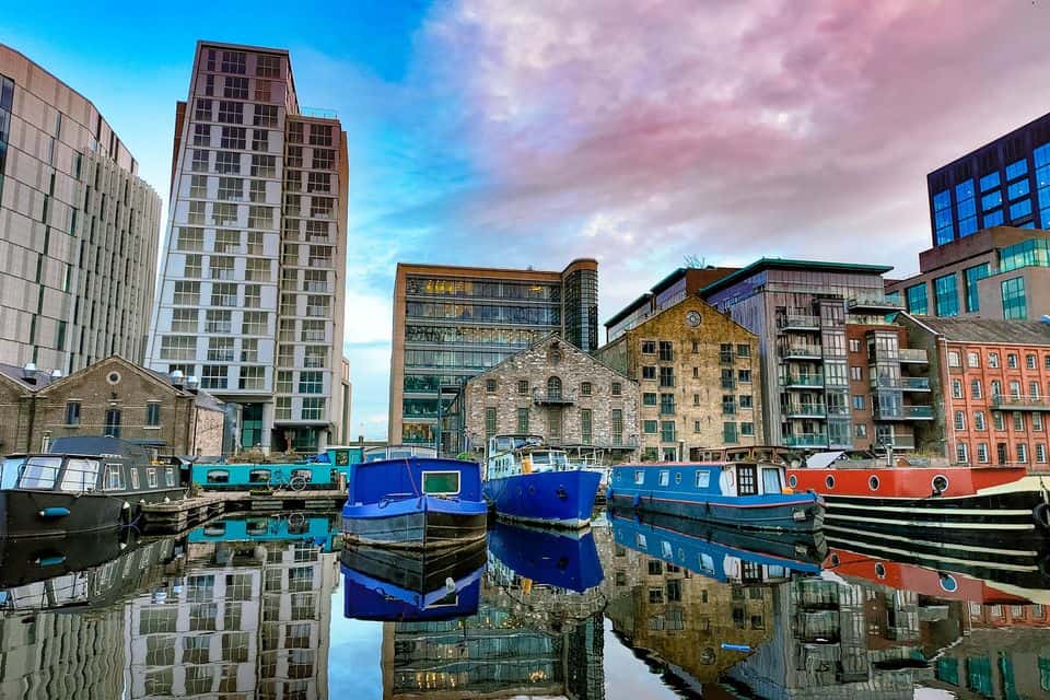
The Dublin Docklands walk showcases the city’s transformation from industrial port to modern urban quarter. Begin at Grand Canal Square, an architectural gem designed by Martha Schwartz with its striking red “carpet” extending toward the water. The nearby Bord Gáis Energy Theatre creates a dramatic backdrop with its angular glass façade.
As you stroll northward, cross the iconic Samuel Beckett Bridge, designed to resemble a harp—Ireland’s national symbol. The bridge offers excellent photo opportunities of both the modern Docklands and traditional Dublin. Continue along the River Liffey’s north bank, enjoying views of the Convention Centre’s tilted cylindrical form and the historic Custom House.
The walk passes through areas rich in maritime history, with informative plaques explaining the docklands’ past as a bustling port. Watch for public art installations scattered throughout the area. The route is particularly magical at dusk when office buildings illuminate and reflect in the water.
After your walk, rest your feet at The Ferryman Pub on Sir John Rogerson’s Quay, a traditional Victorian tavern offering hearty Irish fare and a wide selection of local beers with riverside views.
Phoenix Park Perimeter Walk
- Distance: ~11 km loop
- Difficulty: Moderate (long but mostly flat terrain)
- Duration: 3-4 hours
- Notable Features: Wild deer herds, Victorian gardens, Dublin Zoo, Áras an Uachtaráin (Irish President’s residence), Wellington Monument, Magazine Fort
- Best Time: Spring for flowering gardens; autumn for rutting deer and colorful foliage
- Transport: Bus routes 25, 26, 46A, or 66 to park entrances
- Facilities: Visitor centre with toilets, multiple cafés within the park
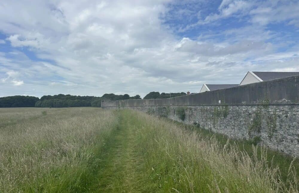
Phoenix Park, one of Europe’s largest enclosed urban parks at 707 hectares (1,750 acres), offers a serene escape from city life. This extensive loop follows the park’s perimeter, providing varied landscapes and wildlife encounters throughout the seasons.
Start at the impressive Parkgate Street entrance with its ornate Victorian gates. Heading west, you’ll pass the Wellington Monument—Ireland’s largest obelisk at 62 meters—commemorating the Duke of Wellington’s military achievements. Continue along the northern edge where you’re likely to encounter some of the park’s 600 fallow deer, descendants of animals introduced in the 1660s.
The path passes Áras an Uachtaráin, official residence of Ireland’s President, where you can glimpse the elegant building through the trees. Nearby, the beautiful Victorian People’s Flower Gardens display meticulously maintained seasonal blooms and an ornamental lake.
Along the southern boundary, you’ll see Dublin Zoo, one of the world’s oldest zoos (founded 1831). The walk continues past the Magazine Fort, built in 1734 to store gunpowder, before returning to your starting point.
After completing the loop, the Phoenix Park Café near the Visitor Centre offers excellent homemade cakes and light lunches using locally sourced ingredients—perfect for replenishing your energy after a long walk.
Coastal Walks near Dublin
Howth Cliff Walk
- Distance: ~6 km loop (shorter options available)
- Difficulty: Moderate (narrow paths, some steep sections, uneven terrain)
- Duration: 2-3 hours
- Notable Features: Dramatic sea cliffs, wildlife spotting, panoramic views of Dublin Bay, Ireland’s Eye island, Howth Harbour, Baily Lighthouse
- Best Time: Spring to autumn; avoid foggy days when views are limited
- Transport: DART train to Howth station (30 mins from city center)
- Facilities: Toilets at Howth Harbour, multiple cafés in Howth village
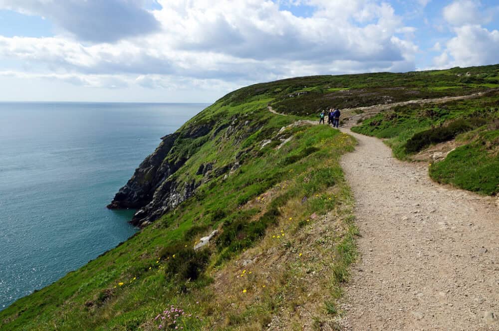
The picturesque fishing village of Howth offers one of Dublin’s most spectacular coastal walks. This loop trail follows rugged cliff paths with breathtaking views across Dublin Bay to Wicklow Mountains beyond.
Begin in Howth village, following signs to the cliff path near the DART station. The trail climbs gradually, opening up magnificent vistas of Howth Harbour and Ireland’s Eye—a small uninhabited island that’s a sanctuary for seabirds including puffins, gannets, and guillemots. Bring binoculars for wildlife spotting!
As you progress, the path hugs increasingly dramatic cliff edges (keep children close) with wildflowers adorning the slopes in spring and summer. Watch for seals in the waters below and kestrels hovering overhead. The trail passes the Baily Lighthouse, built in 1814, standing sentinel on a rocky promontory.
The loop returns through Howth Summit and down to the village through shaded woodland. In season, keep an eye out for wild blackberries and sloes along the path.
After your cliff adventure, The Bloody Stream pub near the DART station offers excellent seafood caught fresh from Howth’s fleet, along with traditional Irish music on weekends. Their seafood chowder paired with brown bread makes for a perfect post-walk meal.
Bray to Greystones Cliff Walk
- Distance: ~7 km one-way
- Difficulty: Moderate (uneven paths, some exposed sections)
- Duration: 2-2.5 hours
- Notable Features: Spectacular sea views, wildlife, cliffside trails, beaches at both ends
- Best Time: Late spring to early autumn; avoid windy days due to exposed sections
- Transport: DART train to Bray, return by DART from Greystones (trains run regularly)
- Facilities: Toilets and refreshments available in both towns

This stunning linear coastal walk connects two charming seaside towns via a well-maintained cliff path offering constant sea views. The route was originally built in the 1880s to facilitate the construction of the railway line that runs below.
Start from Bray Promenade, heading south toward Bray Head. The path climbs steadily alongside the railway tracks, providing increasingly expansive views across Dublin Bay. As you round Bray Head, the terrain becomes more rugged with the path carved into the cliff face.
The middle section traverses slopes covered with gorse and heather, attracting numerous butterfly species in summer. Look out for peregrine falcons nesting on the cliffs and, if you’re lucky, dolphins or porpoises in the water below. The route passes through areas rich in geological interest, with informative signs explaining the rock formations.
The final stretch descends gently to Greystones, a more upscale seaside town with a charming main street. The Beach House café on Greystones seafront makes an ideal stopping point, offering excellent coffee and homemade cakes on their sea-view terrace. Their avocado toast with poached eggs is particularly popular with walkers refueling after the cliff path.
Mountain and Forest Walks
Ticknock Mountain Trail
- Distance: ~5 km loop
- Difficulty: Moderate to challenging (steep ascents, rocky paths)
- Duration: 2 hours
- Notable Features: Panoramic city views, ancient stone monuments, forest trails, Dublin Mountains landscape
- Best Time: Spring to autumn; clear days for best views
- Transport: Dublin Bus 44B weekends only; car recommended
- Facilities: Small car park at trailhead, no toilets or refreshments on site
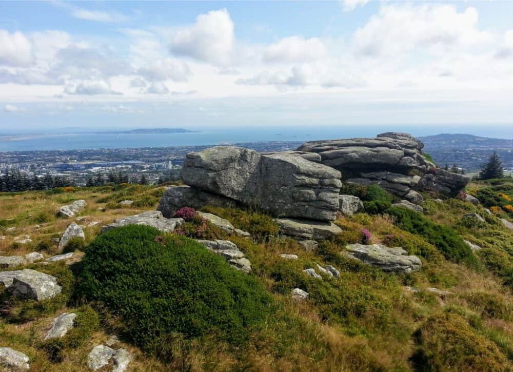
Ticknock Forest Park offers one of the best views over Dublin city from the Dublin Mountains, just a short drive from the city center. This trail combines dense woodland, open mountain heath, and incredible panoramic vistas.
The walk begins at the Ticknock car park, following a clear trail through pine forest before climbing to open mountainside. The ascent to Three Rock Mountain (448m) is moderately steep but rewards with spectacular 360-degree views—Dublin city and bay to the north, the Wicklow Mountains to the south, and on clear days, the mountains of Wales visible across the Irish Sea.
At the summit area, you’ll find prehistoric stone monuments including Bronze Age burial cairns dating back approximately 5,000 years. The loop returns through varied forest sections with glimpses of deer and native bird species.
After descending, drive 10 minutes to Johnny Fox’s Pub in Glencullen—reputedly Ireland’s highest pub at 470m above sea level. This atmospheric 18th-century establishment offers traditional Irish cuisine, live folk music, and dancing most evenings. Their Irish stew paired with fresh soda bread is particularly satisfying after a mountain walk.
The Hellfire Club and Massey Woods
- Distance: ~4 km loop
- Difficulty: Moderate (steady uphill sections)
- Duration: 1.5-2 hours
- Notable Features: Historic ruins with ghostly legends, panoramic views, ancient woodland
- Best Time: Autumn for colorful foliage or summer evenings for atmospheric sunsets
- Transport: Car recommended; limited bus service
- Facilities: Car park, picnic area, no toilets on site

This intriguing walk combines fascinating history, alleged supernatural activity, and beautiful forest landscapes. The centerpiece is the infamous Hellfire Club—a hunting lodge built in 1725 that became associated with aristocratic debauchery and occult practices.
Begin at the Hellfire Club car park, following the clearly marked trail uphill through conifer plantations. The path emerges onto open mountainside with increasingly impressive views across Dublin city, bay, and beyond. The Hellfire Club building stands at the summit of Montpelier Hill (383m), its roofless stone walls creating an eerie silhouette.
Take time to explore the ruins (respectfully) and read information boards detailing the colorful history and legends associated with the building—stories of devil worship, wild parties, and ghostly occurrences abound. The site was built on a prehistoric passage tomb, adding to its mystical significance.
The route continues down through Massey Woods, a mixed woodland with some ancient native trees and the remains of the Massey Estate, including ornamental gardens and bridges. The forest is particularly beautiful in late April/early May when carpeted with bluebells.
After your potentially spooky adventure, Johnny Fox’s Pub (mentioned above) offers a welcome refuge for food and drink amid traditional Irish surroundings.
Lesser-Known Dublin Walks
The Dodder River Walk

- Distance: ~6 km one-way
- Difficulty: Easy to moderate (mostly flat, some uneven sections)
- Duration: 1.5-2 hours
- Notable Features: Riverside wildlife, urban greenery, historic bridges
- Best Time: Year-round; spring for wildflowers
- Transport: Multiple bus routes cross the route; Luas Green Line at Milltown
- Facilities: Several parks with toilets en route, multiple cafés
This peaceful urban riverside walk follows the River Dodder, one of Dublin’s main waterways, through a series of interconnected parks and green spaces. It provides a surprisingly tranquil escape despite being within the city limits.
Start at Bushy Park in Terenure, a beautiful Victorian park with formal gardens and tennis courts. The river path winds northward through woodland sections where you might spot grey herons fishing in the shallows or kingfishers flashing electric blue against the water. Ducks, swans, and occasional otters also inhabit the river.
The route passes through Dartry Park and Orwell Park, crossing several historic bridges including the distinctive yellow Classon’s Bridge. Near Milltown, the path reveals old mill races and weirs, remnants of the river’s industrial heritage when it powered numerous mills.
End your walk at The Dropping Well pub in Milltown, a charming riverside establishment dating from 1847. Their riverside garden offers the perfect spot to enjoy traditional pub fare while watching the Dodder flow by. The seafood chowder and traditional Irish coffee are particularly recommended.
The Great South Wall Walk
- Distance: ~4 km one-way
- Difficulty: Easy (flat, exposed path)
- Duration: 1-1.5 hours
- Notable Features: Poolbeg Lighthouse, sea views, shipping activity, industrial heritage
- Best Time: Summer evenings for sunset views; avoid very windy days
- Transport: Bus to Irishtown/Sandymount, then walk (or drive to limited parking)
- Facilities: No facilities on the wall itself
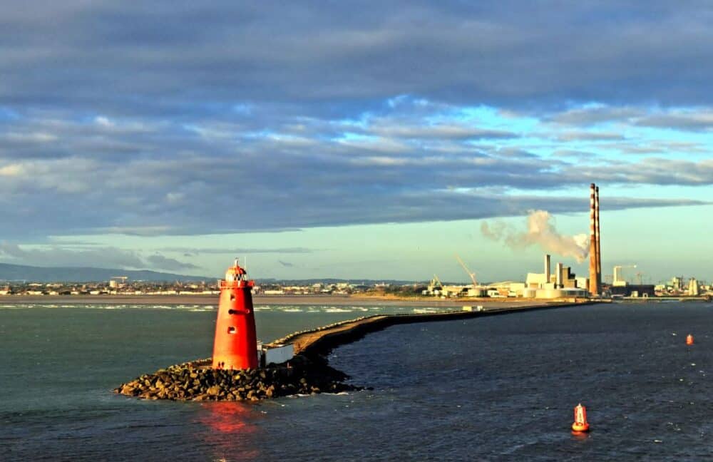
This unique urban walk takes you along an 18th-century granite pier extending 4km into Dublin Bay to the iconic red Poolbeg Lighthouse. The South Wall was an engineering marvel when built (1760-1795) to combat silting in Dublin Bay and reduce shipwrecks.
Begin near Shelley Banks beach, following the straight, flat path that juts dramatically into the bay. The wall provides fascinating perspectives of Dublin from the water, with ships passing close by as they enter and leave the port. Watch for seals, various seabirds, and occasionally porpoises in the water.
The distinctive red Poolbeg Lighthouse (built 1768) stands at the end of the wall, making a perfect turnaround point and photo opportunity. On clear days, you can see the full sweep of Dublin Bay from Howth Head to Dun Laoghaire and the Wicklow Mountains beyond.
The walk feels surprisingly peaceful despite being surrounded by maritime activity and within view of the city. The massive Poolbeg electricity generating station with its twin red and white striped chimneys (known affectionately to Dubliners as the “Poolbeg Stacks”) creates an interesting industrial backdrop.
After returning to shore, The Yacht Tavern in Ringsend offers a welcoming traditional pub atmosphere with excellent Guinness and hearty bar food. Their fish and chips come highly recommended after the sea air has sharpened your appetite.
Frequently Asked Questions About Walking in Dublin
What’s the best time of year for walking in Dublin?
Dublin enjoys a mild maritime climate making walking possible year-round. Spring (April-June) offers pleasant temperatures and blooming landscapes. Summer (July-August) provides longer daylight hours but can be busier on popular routes. Autumn (September-October) delivers beautiful foliage and fewer crowds. Winter walks can be rewarding but prepare for shorter days and potential rain.
Do I need special equipment for these walks?
For city and coastal walks, comfortable walking shoes and weather-appropriate clothing are sufficient. For mountain walks (Ticknock, Hellfire Club), proper hiking boots with ankle support are recommended. Always carry rain gear regardless of the forecast—Dublin weather can change quickly! A small backpack with water, snacks, and a charged mobile phone is advisable for longer routes.
Are these walks suitable for children?
Most walks listed are family-friendly, particularly Phoenix Park, The Dodder River Walk, and sections of the coastal walks. The Howth Cliff Walk and Bray to Greystones have some exposed sections requiring close supervision of young children. Consider shorter versions of longer walks for families with small children.
Can I bring my dog on these walks?
Dogs are welcome on most outdoor trails but must be kept on leads in Phoenix Park due to the wild deer population. Check specific regulations for each location, especially nature reserves. Always clean up after your pet.
Is public transport available to reach these walks?
Dublin has excellent public transport options for reaching most walks. The DART train serves coastal areas including Howth and Bray/Greystones. Dublin Bus routes connect to Phoenix Park and many other starting points. Mountain walks typically have more limited public transport—check schedules in advance or consider car rental.
Are guided walking tours available?
Several companies offer guided walks in Dublin, particularly for the city and historical routes. The Dublin Walking Tour Company and Pat Liddy’s Walking Tours are reputable options. For nature walks, Hill Walking Dublin organizes regular group outings suitable for various fitness levels.
What should I do in case of emergency on remote walks?
For emergencies, dial 112 or 999. If hiking in mountains, inform someone of your planned route and expected return time. The Dublin-Wicklow Mountain Rescue Team covers remote areas around Dublin.
Where can I find detailed maps of these walking routes?
The OSi (Ordnance Survey Ireland) produces excellent detailed maps of all walking areas. The EastWest Mapping Dublin Mountains map is particularly useful for mountain walks. Many routes also have dedicated websites with downloadable maps and GPS tracks.
World Traveling Blogger, Social Media Expert and Nerd who has a passion for Adventure and Fitness.